Biebrzański Park Narodowy - w trosce o bagna


Links
Access facilitation
Zmień język
- Tourism
- Educational Trails
Contents
Educational Trails
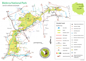
1. Educational trail "Skobla Hill" (Field Educational Centre - Osowiec-Twierdza) - red marks - distance 2 km
The path starts in Osowiec-Twierdza at the Headquarters of the national park. Next passes old flat bloks and turns left into the forest. On the way you can find military shelters and a view tower at the hill. The path ends at the parking lot and “Beaver" camp site.
2. Educational trail "Kładka / Footbridge" - (Field Educational Centre - Osowiec-Twierdza) - green marks - distance 2,2 km
The path starts at the Rudzki Canal in Osowiec-Twierdza. Along the path there are two observation towers, a (nearly 1 km long) footbridge and interpretative boards describing natural and historical curiosities of the area. In the path’s vicinity there are ruins of the XIX century Tsar Fortress (Fort II) from the I WW.
3. Educational trail "Honczarowska Dike" - green marks - distance 3,5 km
Trail starts from the Tsar Road towards Biebrza river (west) and leads throughout varied habitats such as bushes and swampy woods and fen habitats. After 3,3 km walk you can find a view tower there over The Ruff meadow where both birds and flora active protection projects have been carried out. The trail ends at the Pogorzały range (dead end) and returns back towards the Tsar Road.
4. Educational trail "Red Marsh" - wooded walk/black marks - distance 1 km
Trail starts at the so called Sacred Pine (there is a small shrine placed on a tree) next to red marked trail (the old tree eventually fell down in June 2016). It leads throughout transitional bog forest towards a view platform over the Red Marsh strict reserve.
5. Educational trail "Woods" - green marks - distance 3,2 km
The trail starts end finishes at the forester’s lodge "Trzyrzeczki". It leads throughout mixed forest. Along the path you can find interpretative boards describing different aspects of forest ecosystem.
6. Educational trail "Around the Fort IV of Osowiec Fortress" - green marks - distance 4,5 km
Trail starts (ends) at the Tsar Road (7 km away from the Headquarters of the BNP) and leads throughout the pine woods (growing on the dunes) towards the ruins of Fort IV of Osowiec Fortress. After, the trail takes you towards Biebrza valley where you can admire a nice open marsh panorama.
7. Educational trail "Kapice birch woods" - green marks - distance 4,2 km
Trail starts nearby the forester’s lodge Kapice and leads throughout monotype birch woods along Kapice canal. There are interpretative boards placed on the trail describing different natural aspects you can find while visiting this place.
8. Educational trail "Dunes" - green marks, distance 2,3 km
Trail leads throughout the dunes towards New World range and next to a view platform and a view Tower. Along the trail you can find interesting flora typical for sandy conditions. From the view points you can admire vast and open panorama.
News:
Contact data
Osowiec-Twierdza 8,
19-110 Goniądz
phone: +48 857380620,
857383000 ext. 233
fax: +48 857383021
e-mail:
sekretariat@biebrza.org.pl


