Biebrzański Park Narodowy - w trosce o bagna


Links
Access facilitation
Zmień język
- Tourism
- Hiking trails
Contents
Hiking trails
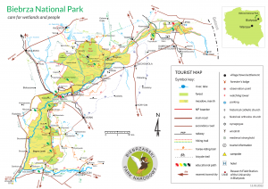
PL -2544-y - yellow
WIZNA - Burzyn - Twierdza Osowiec - GONIĄDZ - 64,3 km – easy, accessible for bikers
The trail begins In Wizna and leads along the egde of Kolno Platue. 10 km after Wizna there is a campsite and a view point there in the village of Burzyn. In the vicinity of the village of Brzostowo and Chyliny you can spot a massive bird migration in spring time. Furhter on the trails leads through the village of Łoje –Awissa, Czachy, Okrasin i Mścichy where one can find interesting wooden architecture. Next, the trail passes the village of Klimaszewnica and reaches the forest complex of Osowiec Protective District of the Biebrza NP. After, the trail crosses the main road and railway line between Ełk and Białystok as well as the Rudzki Canal. Then, it reaches the Field Educational Center – a net of wooden board and view towers. Not far from here there is also a campsite, rooms for rent and kayak rental. Once you get to the end of boardwalk please note there are ruins of Tsar’s Fortress from the IWW. After, trail leads towards Goniądz through small villages of Budne and Wólka Piaseczna. Finally, you pass the Biebrza River and end your trip in Goniądz – the Capital of Biebrza Marshes centrally located in the Biebrza valley (shops, drug store, medical service, church, bus stop, B&B, post office, cash machine, restaurants and bars).
PL-2551-n - blue
FORT II (Osowiec Stronghold) - Goniądz - Dolistowo - Jagłowo - Trzyrzeczki - Jałowo - LIPSK - 85,3 km – easy, accessible for bikers (discluding distance between Jagłowo and Rutkowszczyzna and Kamienna Stara and Szuszalewo).
The trail starts near the ruins of the 2. Fort of the Osowiec Stronghold. After 700 m you cross the wooden bridge over Biebrza river. Further it leads towards the headquarters of the Biebrza National Park with Tourist Information and visitors certre. One goes south-eastwards between the Osowiec rail station and the military area. Follow the dirt road along the moat on the left till you reach the crossroads with the asphalt road. The trail continues on the Tsars Road, passes Goniądz and Dolistowo Stare and goes across the river towards Dębowo Lock on the Augustowski Canal (built in years 1826-27) and further to Jagłowo - a small village with interesting architecture. Next the trail continues to the village of Rutkowszczyzna and Trzyrzeczki, passes nice mixed woods and reaches village of Kamienna Nowa and Kamienna Stara. After 130,7 km the trail ends in Lipsk - center of painted Eastern eggs.
PL-2599-y yellow
LASKOWIEC- Zajki - Słomianka - Łazy - Kiślaki - Łaziuki - Piaski - Tatary - TYKOCIN - 20,5 km – easy, accessible for bikers
Trail begins in Laskowiec Village on the Tsar Road and follows the right edge of the Narew River. Trail passes nice, traditional landscape and small villages up to the main road between Knyszyn and Tykocin. There it turns right towards Tykocin, passes Narew river and ends at the Stefan Czarnecki square. In Tykocin you can find objects of cultural heritage: old church, synagogue and other buildings.
PL-2549-c red
GUGNY - BARWIK - 9,5 km – sometimes difficult
A path starts close to the blue trail at Dobarz village, passes at observation platform (possibility to see Great Snipe displaying), observation tower at the “Występ Range”, crosses the Kosódka River and reach Gugny village. BEWARE: this trail can be flooded during the spring. Tourists will have difficulty walking this trail at that time.
PL-2550-y yellow
TRZCIANNE - Werykle - Chojnowo - Gugny - Stójka - Nowa Wieś - TRZCIANNE - 20,5 km – easy, accessible for bikers
It goes through scenic lanscape of fields and forests. On the trail you can admire interesting fragments of rised bog.
PL-2577-z green
SUCHOWOLA - Okopy - Karpowicze - Jatwieź Mała - Trzyrzecze - Skindzierz - Zagórze - Korycin - JANÓW- 66 km - easy
PL-258-z green
AUGUSTÓW - Jastrzębna -LIPSK -78,3 km - easy, accessible for bikers on the distance of 46.9 km
It goes from Wrotki village along BNP outline border through Jaminy (wooden church from the end of 18th century), Czarniewo, Czarny Las, Sztabin and Krasnybór (Gothic-Renaissance church, 1591) and reaches Jastrzebna village. The next part of the trail passes through Ostrowie Biebrzańskie, Nowy Lipsk and stops at Lipsk.
PL-2540-c - red
RAJGROD - Okoniowek - Rybczyzna - Woznawies - Grzędy forest lodge -"Nowy Swiat" -"Wilcza Gora" - "Kapli Dolek" -"Dzial Kumkowskiego" – trail junction - 41.6 km - easy, sometimes wet, accessible for bikers between Rajgród and Nowy Świat
It starts at the foot of the Castle Hill (Jacwing’s stronghold from XII c.) in Rajgrod and goes along the edge of the Rajgrodzkie Lake to Augustów-Grajewo road. Crossing this way, the trail runs with the forest route to Rybczyzna village at the Dreństwo Lake. Trail goes along the edge of this lake, passes through Woznawies village and reaches the Biebrza National Park and stritly protective zone of “Red Marsh”. The trail goes from the Grzedy forest lodge along the forest road to the New World (Nowy Swiat) range, and further through the Wilcza Gora range to Tchórze Grzędy range (observation tower with scenic view to the open sedge areas). The next part of the trail runs through peatlands to “Kapli Dolek” spot (black trail on the right), dunes and marshes at Grabowski and Kumkowski Range. It finishes at trail junction (the end of green trail).
PL-2541-y yellow
TAMA - Kuligi - Orzechowka -"Borek" -Polkowo -Dębowo - Jasionowo -Kopytkowo -"NOWY SWIAT" -38,5 km – easy, accessible for bikers on the distance between Tama – Orzechówka
The trail begins at the bus stop in Tama and leads through the woodland towards Woźnawieś. After the distance of three km the trail turns to the right towards Kuligi, passes the village, goes across Jegrznia river and turns onto gravel road to Orzechówka. After, the trail goes around Red Marsh reserve, continues along the Augustowski Canal towards (Attention – in spring very difficult access due to flooding) Polkowo and Dębowo. In Dębowo there is an old lock on the Augustowski Canal. Next, the trail continues towards Kopytkowo. From here the trail turns towards Red Marsh reserve (trail usually is flooded in spring) and continues to Nowy Świat range – end of the trail – junction with other trails.
PL-2545-c - red
GONIADZ - Wolka Piaseczna - Kapice - rzeka Elk - RUDA - 29 km - a long and hard trail
This trail will take the whole day to walk. It passes through Goniadz, Wolka Piaseczna, Brzeziny Kapickie forest, Debiec, Modzelowka, and finishes at Ruda. Two significant landmarks are found in Goniadz. The Neo-baroque church built at the beginning of the 20th century and Saint Florian's chapel, located close to church. A great panorama of Goniadz can be viewed from the small ledge just in front of the town's cemetery. During the spring the observation tower (500 m from Goniadz, Wolka Piaseczna direction) provides a second excellent view of the town as well as the surrounding wet meadows. Continuing down the trail to Brzeziny Kapickie. This tree stand complex consists of birches and alders is usually moist all year round. Travelling along the Kapicki Canal, where is possible to observe dam and beaver lodge, the trail passes through a village of the same name. This settlement has remnant of old wooden structures. The trail reaches the Elk River, and goes along its right bank to Dębiec mineral hill (possibilty of camping here) and further to the Rudzki Canal. The trail passes through Modzelowka – a village with a lot of nests of white stork and stops at Ruda village.
PL-2547-z - green
OSOWIEC-TWIERDZA - Przechody - Ciszewo - KULIGI - 37,7 km.
The trail could be very difficult or even not available to pass at a few spots during springtime. It depends on the waters level. The trail is very typical for the Biebrza marshes.
PL-2539-s black
MSCICHY fire brigade base - "BIALY GRAD" campsite It starts at Mscichy village at Wizna - Goniądz yellow trail. Passing the village, the route goes with dam among meadows to “Biały Grad” camping site with observation tower. Trail is not available to pass during early springtime.
PL-2543-z - green
GRZEDY FOREST LODGE- "Solistowska Gora" - "Lagiew" – trail junction (watering place at the Polish Horse Breeding Farm) - 7 km – easy, sometimes wet
It starts at Grzędy forest lodge. It goes with dam into east direction and at mixed forest turn to dune at Solistowska Hill (spot where the inhabitants of the village of Grzędy were killed by the Nazist). The route takes you to the marshes at the Polish Horse Breeding Farm and further to the dunes at Kumkowski Range and Łągiew. The next part of the trail goes along the fence of the Polish Horse Breeding Farm. The trail finishes at trail junction.
PL-2542-n blue
LESNICZOWKA GRZEDY- "II i III Grzeda" - "KAPLICZKA" - 4,7 km - easy
It starts at Grzędy forest lodge. The route goes through forest area into east direction and reaches the boardwalk with interpretation boards in the heart of pine bog forest on rised bog.
PL-2544-s - black
"UROCZYSKO DEBY"- "Gora Partyczyzna" - "Kapli Dolek" -2,2 km – easy
The trail goes from Kapli Dołek (red trail) to the parking spot at Dęby (Oak) range.
Please note that the English version of the Biebrza National Park’s website is currently under construction. We do our best, but some information may be not updated yet.
News:
Contact data
Osowiec-Twierdza 8,
19-110 Goniądz
phone: +48 857380620,
857383000 ext. 233
fax: +48 857383021
e-mail:
sekretariat@biebrza.org.pl


